BranTrips routes
Enjoy the wonderful scenery of the Bran area on two wheels. You have the freedom to choose for yourself the route you want to take.
- Home
- Trasee
Our recommendations
The hills and the view will conquer you regardless of whether you are looking for a route with a low degree of difficulty or if you like to go on unpaved mountain paths. Our team offers dynamic routes and a variety of tourist attractions that you can visit.
Whether you want to venture out alone with family or friends, our bikes are an inspired choice. On two wheels, you will save the money you would have spent on car fuel and you will contribute to protecting the environment.
The possibilities to go on bike routes are very well outlined by the Administration of the Piatra Craiului National Park, there are a number of 11 very well defined and marked routes. The necessary maps for tourists are offered on the Administration’s website, in digital format.
Zârnești - Plaiul Foii Chalet - blue on the indicator arrows
Distance: 12 km
Difficulty level: easy
Easy route, with a length of 12 km and with special views over the steep northwest of Piatra Craiului, furrowed by numerous torrential valleys called “padine”, characteristic of this limestone massif. The route is partially paved (currently 5 km long), but there is an ongoing project to fully pave this road. Next to the Tourist Information Center from Zârnești, located right in the center of the locality, there is an indicator with the direction of Plaiul Foii that will take you out of the city on the Bârsa Mare Valley. After about 2 km you will see on the right side the building of the Administration of the Piatra Craiului National Park, which also houses the Visitor Center where you can get information about the tourist attractions and the regulations of the protected area. Continue past Valea Crăpăturii and the intersection with the road to Colții Chiliilor, located on the left side in your walking direction. At km 6.5 you meet on the right a first tributary of Bârsa – Bârsa Fierului, and after another 4 km you reach Gura Bârsei where the Bârsa lui Bucur brook flows, another tributary of Bârsa. From here the forest road leads you to the left, accompanying the watercourse. Soon you reach the final point of the route, Plaiul Foii chalet, located right next to the place where, by joining Bârsa Groșetului with Bârsa Tamașului, Bârsa Mare is formed. Near the cottage there is a surveillance point and mount rescuer.
Zârnești - Colții Chiliilor - black on the indicator arrows
Distance: 4.8 km
Difficulty level: difficult
Difficult route, recommended for experienced cyclists because it has single-trail sections on narrow paths, with roots and boulders. The initial part is common with the first route, but after only 1 km the tourist route marked with a blue stripe that leads you to the hermitage from Colții Chiliilor detaches on the left side. This intersection is signaled by a signpost. The cart road crosses the agricultural lands, then follows a short climb on the terraces at the base of the northern slope of Piatra Mica (“Sub Barc”). Next, the road follows approximately the level curve, crossing the meadows mowed in summer by the locals, before turning into a narrow path, with roots and boulders, which will test the technical skills of cyclists. After crossing the Crăpătura Valley, the path will intersect the forest road that climbs directly from Valea Bârsei (road that you will follow on your return) and will not present any technical difficulties until the end. Going down the forest road can cause problems in wet weather. At Colții Chiliilor there is a spring, necessary for the restoration of water supplies.
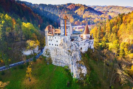
Zârnești - Bran Castle - blue on the indicator arrows
Distance: 8.7 km
Difficulty level: easy
Easy route, which connects Zârnești and Bran. From the Tourist Information Center in Zârnești, located right in the center of the town, follow the road signs with the direction of Brașov for a distance of several hundred meters, then turn right next to a sign with the direction of Bran. Cross the Caraiman block of flats and continue your way straight ahead on Bran Road. After leaving the last houses, the asphalt leaves room for a paved road that will start to climb towards Tohănița. While pedalling and gaining altitude, you can admire Saua Măgurii , Piatra Mică and the city of Zârnești. You soon see the first houses in Tohănița and the ascent is over, once you return to the paved road. You are now heading towards Bucegi, with Măgura Branului on your right, at the foot of which were formerly the old Austrian border cordon and the Bran customs. From Predeluț, a quick descent will take you in a short time to the park in front of Bran Castle, the summer residence of Queen Maria. There is also a water source in the park, but you can easily refuel from the many shops in the area.
Zârnești - Abysses - La Table - Saua Joaca - Cave - Măgura - Zârnești - red on the arrow keys
Distance: 12 km
Difficulty level: medium
Route of medium difficulty, but with spectacular landscapes. It is a route identical to the one to the Curmătura chalet until the exit from the gorges. After a section of serpentines, leave the road to Curmătura chalet, a curve to the left leading you to Vlădușca and Table glade. A short descent and continue your ascent to the end of the exploitation road. From here, a marked path starts through the forest that crosses the Vlădușca glade to La Table point, an intersection point for several tourist routes, near which there is a spring. Turn left and head towards Șaua Joaca, climbing steadily on a tractor road. The descent to the village of Peştera is very rocky and requires caution to avoid injuries. Just before Casa Folea, the tourist route descends in the village of Măgura, at the foot of Mount Toancheș. From here the road follows Coțurile Măgurii and descends to Botorog’s Fountain, completing the loop.
Zârnești - The precipices - La Table - Dâmbovicioara - Ciocanu - Șirnea - Cave - Măgura - Zârnești - black on the arrow keys
Difficulty level: difficult
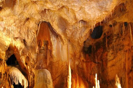
Difficult route due to the level difference. The route is common with the previous route to La Table point, from where it continues to Grind and then descends to Brusturet on a rocky road through Valea Seacă a Pietrelor. Near La Table point there is a spring, necessary for rehydration and restoration of water supplies. From the Brusturet chalet, descend on a forest road to Dâmbovicioara, first crossing the spectacular gorges of Brusturet. You will soon reach the Dâmbovicioarei Cave, one of the main attractions of the area, visited since the 15th century. XVIII. After visiting the cave, continue your descent to an intersection where a demanding ascent on asphalt to Ciocanu village begins. At the entrance to Brașov County, the asphalt ends and the descent to the village of Șirnea begins. From the center of the locality you turn left and soon intersect with route no. 6, which has the same route from this point to Zârnești.
Zârnești - Abysses - La Table - Curmătura Groapelor - Șirnea - Peştera - Măgura - Zârnești - red on the indicator arrows
Difficulty level: medium
Route of medium difficulty, but very varied. The route is common with route no. 4 to Șaua Joaca from where it separates on the right side and crosses a meadow, before descending on a tractor road to the cobbled road that goes up to Curmătura Groapelor, through which passed the old border between Romania and the Austro-Hungarian Empire and from where to admire a spectacular view over the mountain villages and the Bucegi Mountains. The descent in the village of Șirnea on Frunteș’s road is very rocky and requires caution to avoid possible injuries. At the end of the road turn left, being forced to open a gate that limits the access of cattle. After another descent, there is a short but very steep climb that takes you to the paved road that goes up from Moeciu to the village of Peştera. On the way up, on the right side, there is a spring that can be used to restore water supplies. From the end of the asphalt road, the route descends to the village of Măgura, then to Botorog’s Fountain and, finally, to Zârnești, thus completing a complex tour.
Zârnești - Măgura - Cave - Moieciu de Jos - Măgura - Zârnești - red on the indicator arrows
Difficulty level: medium
Medium difficulty route. The route is identical to route no. 8 to the right of the Valley with the Way, from where it continues straight ahead, crossing the village of Măgura to the top of the Zârnești precipices. After a short descent, there is another steep climb to the village of Peştera, where you meet the paved road. During the climb you can admire the traditional architecture of the mountain village, but also the meadows full of multicolored flowers, mowed in summer by the locals, and in the background the Bran slope of the Bucegi Mountains and the eastern slope of Pietra Craiului. From the Cave begins a rapid descent on asphalt to Moieciu which must be approached with caution due to tight turns and the fact that very high speeds can be reached here. Also, especially at the end of the week, car traffic is growing a lot in this sector. Also in this area is the Bat Cave, which also gave the name of the town. At the end of the descent, you will soon intersect with route no. 4, whose path you will follow again until the end.
Zârnești - Măgura - Valea cu Calea - Măgura - Zârnești - black on the indicator arrows
Distance: 17 km
Difficulty level: medium
Difficulty level: medium
Medium difficulty route where the short distance is compensated by the level difference. Up to the Magurii Bridge, the route is identical to the one described at no. 4. From here turn left and climb on Coturile Măgurii to the village. After about 3 km the climbing ends and you leave the forest. There follows a short descent during which we can admire the traditional architecture of the mountain village and the steep Brânean of Bucegi. Turn left and cross the village to Valea cu Calea, where an indicator signals on the left the beginning of a spectacular descent to Moeciu de Jos. The route will test the technical skills of cyclists due to the steep slope and deep gorges dug by the rains. There are a few crossings through the water, seasoned with puddles full of mud. Once at the end of the valley, turn left and follow the paved road to the intersection with Valea Pescarului where there is an information panel. From here, a forest road climbs to the village of Măgura, passing some relays and offering you spectacular views of the Bran lands, and at the end of the climb you close the loop, before descending back to Zârnești.
Zârnești - Păpăstii - Curmătura Chalet - Zârnești - black on the indicator arrows
Distance: 19.4 km
Difficulty level: difficult
Difficult route due to the level difference. From the right of the Tourist Information Center from Zârnești, follow the signs to Măgura and Prăpăstii that will direct you to the Gura Răului chalet where the asphalt road ends and a forest road on Valea Răului begins. After a short climb you cross a former stone quarry and soon meet a place arranged for camping and picnic activities. Immediately after the curve, on the right side, there is the Botorog Fountain, where the water supply can be made. At Podul Măgurii, leave the road that goes up to the village on the left and continue your route straight ahead towards the gorges, passing the water catchments and the guard’s house. You will soon reach the entrance between the precipices, where a barrier limits car access in this spectacular key sector. The paved road begins to climb steadily through the limestone walls that house many black goats. After a sector with serpentines, at the exit of the gorges, leave the road to Vlădușca on the left and continue with a short ascent, before turning right towards the Curmătura chalet. Two steep sections, named Panta Mare and Panta Mică by locals, are a challenge for cyclists with climbing skills. Next to the cottage there are two springs that serve to rehydrate and restore water supplies. A long descent back to Zârnești is the reward for the effort made so far.
Dâmbovicioara - Podu Dâmboviței - Sătic - Garofița Pietrei Craiului Cottage - blue on the indicator arrows
Distance: 21 km
Difficulty level: easy
Easy route, recommended for all categories of cyclists. From the intersection with the road to Ciocanu village follow the paved road along the Dâmbovicioara valley, crossing a spectacular sector of gorges, and reach Podu Dâmboviței at the national road where you turn right, cross the bridge that gave the name of the locality and enter Cheile Dâmboviței , where the asphalt ended. At the exit of the gorges you meet the first houses from Sătic, then pass by a dam and continue your way along Dâmbovița until the intersection with Valea Dragoslovenilor where you cross to the right over a bridge. The installed barrier limits car access, and the ascent to Garofița Pietrei Craiului Cottage becomes steeper and you can see signs of the presence of wildlife. Arriving at the cottage, you can admire the steep limestone walls, extremely photogenic in the sunset light. A walk to Marele Grohotiș and Cerdacul Stanciului can complete this tour, giving you the opportunity to meet the black woodpeckers and the rich flora of Pietra Craiului.
Dâmbovicioara - Valea Cheii - Fundățica - Fundata - Șirnea - Ciocanu - Dâmbovicioara - red on the indicator arrows
Difficulty level: medium
It is a route of medium difficulty. From the starting point, the route is common with route no. 10, from which it separates at Podu Dâmboviței, following the European road for a distance of several hundred meters, before leaving the paved road and turning right, entering again the territory of the Piatra Craiului National Park. After crossing a key sector, cross the Key Valley on a forest road and start climbing towards Fundata. The signposts signal your direction at intersections and, after a steep climb, you reach Fundata where the paved road resumes. At the intersection with the European road, turn left, towards Rucar, but after only a few hundred meters turn right, towards Șirnea on a tractor road. You will soon reach the recently paved road that leads you to the center of the village. A last section of paved road goes up to the village of Ciocanu where we meet again the asphalt road. A quick descent brings you back to the starting point in Dâmbovicioara, thus completing the circuit.